A new exciting exhibition is now ready in the Coopmanshuys: ‘Edam Then and Now,’ featuring the ‘Blaeu Map.’
The creators of this permanent exhibition about the origins of Edam and its trade and lifestyle are residents Chrisje and Kees Brants, as well as Leendert de Jonge. They examined and dissected the map, an enormously enlarged version of the city plan by Amsterdam cartographer Joan Blaeu from 1697, down to the smallest detail. The houses, churches, inns, other businesses, waterways, bridges – all are meticulously depicted on Blaeu’s map. Thirteen shipyards in the middle of the city, farms, and orchards, stacks of logs and mills indicating the timber trade (Nieuwehaven), the large ovens at the Oorgat where seawater was boiled to make salt, a tiny horse for the towboat on the Schepenmakersdijk, the Cheese Weighhouse in its original location at the Damplein…
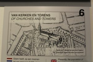
When Edam obtained city rights (1357), it had at most 40 houses and 160 inhabitants. Much has changed over the centuries – and this is explained on 14 large panels and in the audio tour, recorded in the sound studio of Simon Gitsels at ‘Dwars’ on the Voorhaven. Additionally, the tour is available in two languages: Kees Brants recorded the Dutch version, while his wife Chrisje did the English version. Finally, the indispensable Steef Reilingh further arranged the Blaeu exhibition with relevant objects: it is definitely worth a visit.